


Le gd Echaillon Col de la Bataille

verozerr
User
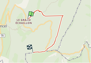

Length
5.6 km

Max alt
1340 m

Uphill gradient
306 m
Km-Effort
9.2 km

Min alt
1152 m

Downhill gradient
146 m
Boucle
No
Creation date :
2025-07-17 10:33:28.386
Updated on :
2025-07-17 16:37:56.481
4h37
Difficulty : Medium

FREE GPS app for hiking
 SityTrail
IGN / Geographical institutes
SityTrail Plus
The world is yours!
About
Trail Walking of 5.6 km to be discovered at Auvergne-Rhône-Alpes, Drôme, Léoncel. This trail is proposed by verozerr.
Description
par la route de
Positioning
Country:
France
Region :
Auvergne-Rhône-Alpes
Department/Province :
Drôme
Municipality :
Léoncel
Location:
Unknown
Start:(Dec)
Start:(UTM)
674514 ; 4975834 (31T) N.
Comments