


Gaël court avec variante

PatriceCocuaud
User
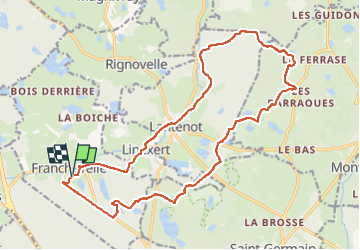

Length
19.9 km

Max alt
436 m

Uphill gradient
344 m
Km-Effort
25 km

Min alt
296 m

Downhill gradient
344 m
Boucle
Yes
Creation date :
2025-07-18 07:26:43.788
Updated on :
2025-07-18 10:01:56.606
2h22
Difficulty : Easy

FREE GPS app for hiking
 SityTrail
IGN / Geographical institutes
SityTrail Plus
The world is yours!
About
Trail Mountain bike of 19.9 km to be discovered at Bourgogne-Franche-Comté, Haute-Saône, Franchevelle. This trail is proposed by PatriceCocuaud.
Positioning
Country:
France
Region :
Bourgogne-Franche-Comté
Department/Province :
Haute-Saône
Municipality :
Franchevelle
Location:
Unknown
Start:(Dec)
Start:(UTM)
309561 ; 5290303 (32T) N.
Comments