


Trace Gaube G3 Guy 180725

mitch1952
User
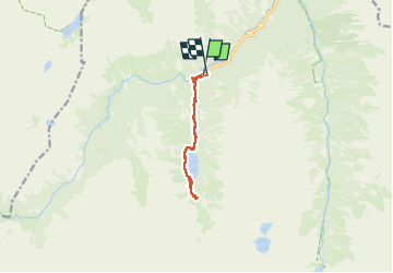

Length
10.9 km

Max alt
1787 m

Uphill gradient
398 m
Km-Effort
16.2 km

Min alt
1465 m

Downhill gradient
397 m
Boucle
Yes
Creation date :
2025-07-18 07:31:01.0
Updated on :
2025-07-18 14:08:58.742

FREE GPS app for hiking
 SityTrail
IGN / Geographical institutes
SityTrail Plus
The world is yours!
About
Trail of 10.9 km to be discovered at Occitania, Hautespyrenees, Cauterets. This trail is proposed by mitch1952.
Positioning
Country:
France
Region :
Occitania
Department/Province :
Hautespyrenees
Municipality :
Cauterets
Location:
Unknown
Start:(Dec)
Start:(UTM)
734002 ; 4748359 (30T) N.
Comments