


Lac gelé

sdroneau
User
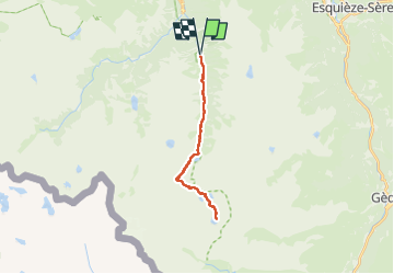

Length
24 km

Max alt
2585 m

Uphill gradient
1281 m
Km-Effort
41 km

Min alt
1369 m

Downhill gradient
1278 m
Boucle
Yes
Creation date :
2025-07-18 05:19:21.133
Updated on :
2025-07-18 15:51:38.125
6h55
Difficulty : Very difficult

FREE GPS app for hiking
 SityTrail
IGN / Geographical institutes
SityTrail Plus
The world is yours!
About
Trail Walking of 24 km to be discovered at Occitania, Hautespyrenees, Cauterets. This trail is proposed by sdroneau.
Positioning
Country:
France
Region :
Occitania
Department/Province :
Hautespyrenees
Municipality :
Cauterets
Location:
Unknown
Start:(Dec)
Start:(UTM)
737092 ; 4748650 (30T) N.
Comments