


aurons 2010

hollier-larousse
User
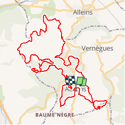

Length
31 km

Max alt
328 m

Uphill gradient
737 m
Km-Effort
41 km

Min alt
148 m

Downhill gradient
720 m
Boucle
Yes
Creation date :
2014-12-10 00:00:00.0
Updated on :
2014-12-10 00:00:00.0
--
Difficulty : Unknown

FREE GPS app for hiking
 SityTrail
IGN / Geographical institutes
SityTrail Plus
The world is yours!
About
Trail Mountain bike of 31 km to be discovered at Provence-Alpes-Côte d'Azur, Bouches-du-Rhône, Aurons. This trail is proposed by hollier-larousse.
Positioning
Country:
France
Region :
Provence-Alpes-Côte d'Azur
Department/Province :
Bouches-du-Rhône
Municipality :
Aurons
Location:
Unknown
Start:(Dec)
Start:(UTM)
673844 ; 4836711 (31T) N.
Comments
Super, le caronte est toujours aussi exigent surtout quand il fait chaud!