


loge supeyres 28k v2

ophness
User
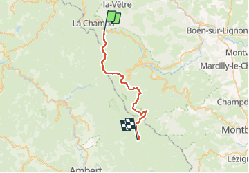

Length
28 km

Max alt
1433 m

Uphill gradient
644 m
Km-Effort
36 km

Min alt
1203 m

Downhill gradient
528 m
Boucle
No
Creation date :
2025-07-18 19:27:50.168
Updated on :
2025-07-18 19:27:54.298
4h43
Difficulty : Difficult

FREE GPS app for hiking
 SityTrail
IGN / Geographical institutes
SityTrail Plus
The world is yours!
About
Trail Horseback riding of 28 km to be discovered at Auvergne-Rhône-Alpes, Loire, Chalmazel-Jeansagnière. This trail is proposed by ophness.
Positioning
Country:
France
Region :
Auvergne-Rhône-Alpes
Department/Province :
Loire
Municipality :
Chalmazel-Jeansagnière
Location:
Jeansagnière
Start:(Dec)
Start:(UTM)
560675 ; 5065719 (31T) N.
Comments