


Montée Barèges-Tournaboup

hugha
User
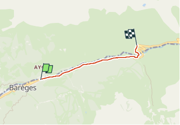

Length
3.3 km

Max alt
1515 m

Uphill gradient
265 m
Km-Effort
6 km

Min alt
1256 m

Downhill gradient
14 m
Boucle
No
Creation date :
2025-07-19 10:45:42.0
Updated on :
2025-07-19 11:35:44.264

FREE GPS app for hiking
 SityTrail
IGN / Geographical institutes
SityTrail Plus
The world is yours!
About
Trail of 3.3 km to be discovered at Occitania, Hautespyrenees, Barèges. This trail is proposed by hugha.
Positioning
Country:
France
Region :
Occitania
Department/Province :
Hautespyrenees
Municipality :
Barèges
Location:
Unknown
Start:(Dec)
Start:(UTM)
260652 ; 4753636 (31T) N.
Comments