


MOUSTIER - LE POIL PAR LE CHIRAN

jpb83
User
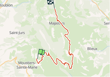

Length
33 km

Max alt
1897 m

Uphill gradient
1589 m
Km-Effort
53 km

Min alt
951 m

Downhill gradient
1333 m
Boucle
No
Creation date :
2015-08-02 00:00:00.0
Updated on :
2015-08-02 00:00:00.0
11h09
Difficulty : Difficult

FREE GPS app for hiking
 SityTrail
IGN / Geographical institutes
SityTrail Plus
The world is yours!
About
Trail Walking of 33 km to be discovered at Provence-Alpes-Côte d'Azur, Alpes-de-Haute-Provence, Moustiers-Sainte-Marie. This trail is proposed by jpb83.
Positioning
Country:
France
Region :
Provence-Alpes-Côte d'Azur
Department/Province :
Alpes-de-Haute-Provence
Municipality :
Moustiers-Sainte-Marie
Location:
Unknown
Start:(Dec)
Start:(UTM)
278608 ; 4859583 (32T) N.
Comments