


haute perche

JEFFV
User
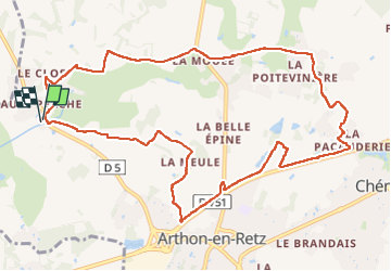

Length
12.2 km

Max alt
15 m

Uphill gradient
68 m
Km-Effort
13.1 km

Min alt
0 m

Downhill gradient
68 m
Boucle
Yes
Creation date :
2025-07-20 06:57:38.04
Updated on :
2025-07-20 10:07:39.319
3h08
Difficulty : Difficult

FREE GPS app for hiking
 SityTrail
IGN / Geographical institutes
SityTrail Plus
The world is yours!
About
Trail Walking of 12.2 km to be discovered at Pays de la Loire, Loire-Atlantique, Chaumes-en-Retz. This trail is proposed by JEFFV.
Positioning
Country:
France
Region :
Pays de la Loire
Department/Province :
Loire-Atlantique
Municipality :
Chaumes-en-Retz
Location:
Arthon-en-Retz
Start:(Dec)
Start:(UTM)
578197 ; 5220083 (30T) N.
Comments