


ysier arches

Louis-59
User
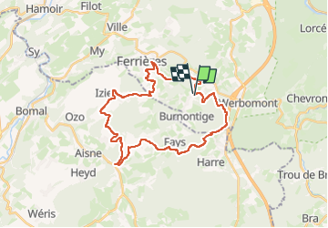

Length
29 km

Max alt
454 m

Uphill gradient
758 m
Km-Effort
39 km

Min alt
199 m

Downhill gradient
762 m
Boucle
Yes
Creation date :
2025-07-20 07:59:02.41
Updated on :
2025-07-20 10:21:37.607
2h12
Difficulty : Difficult

FREE GPS app for hiking
 SityTrail
IGN / Geographical institutes
SityTrail Plus
The world is yours!
About
Trail Mountain bike of 29 km to be discovered at Wallonia, Liège, Ferrières. This trail is proposed by Louis-59.
Positioning
Country:
Belgium
Region :
Wallonia
Department/Province :
Liège
Municipality :
Ferrières
Location:
Unknown
Start:(Dec)
Start:(UTM)
688117 ; 5584637 (31U) N.
Comments