


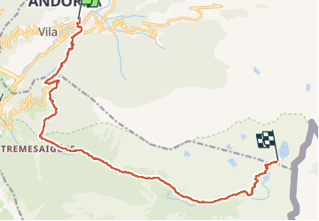
De encamp au refuge de l’Illa
© OpenStreetMap contributors


7h30
Difficulty : Very difficult


Length
16.7 km
Max alt
2490 m
Uphill gradient
1406 m
Km-Effort
31 km
Min alt
1242 m
Downhill gradient
185 m
Boucle
No
Creation date :
2025-07-20 04:36:08.0
Updated on :
2025-07-20 16:20:56.329
7h30
Difficulty : Very difficult
FREE GPS app for hiking
 SityTrail
IGN / Geographical institutes
SityTrail Plus
The world is yours!
About
Trail Walking of 16.7 km to be discovered at Andorra. This trail is proposed by 000549.742464c1b03a4f089954791b77f25409.1417.
Positioning
Country:
Andorra
Region :
Unknown
Department/Province :
Unknown
Municipality :
Unknown
Location:
Unknown
Start:(Dec)
Start:(UTM)
383264 ; 4710240 (31T) N.
Comments