


2025-07-20_20h38m10_PROPOSITION RANDONNEE-AAMG

fwedy
User
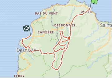

Length
29 km

Max alt
636 m

Uphill gradient
1501 m
Km-Effort
49 km

Min alt
4 m

Downhill gradient
1510 m
Boucle
No
Creation date :
2025-07-21 00:38:10.473
Updated on :
2025-07-24 19:32:43.828
11h06
Difficulty : Very difficult

FREE GPS app for hiking
 SityTrail
IGN / Geographical institutes
SityTrail Plus
The world is yours!
About
Trail Walking of 29 km to be discovered at Guadeloupe, Unknown, Sainte-Rose. This trail is proposed by fwedy.
Positioning
Country:
France
Region :
Guadeloupe
Department/Province :
Unknown
Municipality :
Sainte-Rose
Location:
Unknown
Start:(Dec)
Start:(UTM)
636380 ; 1808149 (20Q) N.
Comments