


Dampierre - Chateauneuf - Les forges - Fraisans et alentours

Maca8284
User
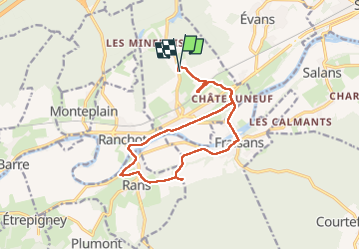

Length
15 km

Max alt
266 m

Uphill gradient
166 m
Km-Effort
17.2 km

Min alt
211 m

Downhill gradient
167 m
Boucle
Yes
Creation date :
2025-07-21 06:16:30.785
Updated on :
2025-07-21 10:11:00.244
3h50
Difficulty : Easy

FREE GPS app for hiking
 SityTrail
IGN / Geographical institutes
SityTrail Plus
The world is yours!
About
Trail Walking of 15 km to be discovered at Bourgogne-Franche-Comté, Jura, Dampierre. This trail is proposed by Maca8284.
Description
Autour du Doubs
Positioning
Country:
France
Region :
Bourgogne-Franche-Comté
Department/Province :
Jura
Municipality :
Dampierre
Location:
Dampierre
Start:(Dec)
Start:(UTM)
707748 ; 5227316 (31T) N.
Comments