


Thieusies et 8 des étangs de St Denis 12,5km

CapTom
User
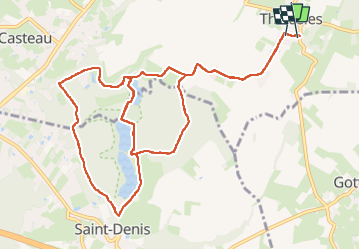

Length
12.5 km

Max alt
110 m

Uphill gradient
160 m
Km-Effort
14.7 km

Min alt
53 m

Downhill gradient
160 m
Boucle
Yes
Creation date :
2025-07-21 07:28:25.0
Updated on :
2025-07-21 10:41:03.834
2h30
Difficulty : Difficult

FREE GPS app for hiking
 SityTrail
IGN / Geographical institutes
SityTrail Plus
The world is yours!
About
Trail Walking of 12.5 km to be discovered at Wallonia, Hainaut, Soignies. This trail is proposed by CapTom.
Positioning
Country:
Belgium
Region :
Wallonia
Department/Province :
Hainaut
Municipality :
Soignies
Location:
Unknown
Start:(Dec)
Start:(UTM)
574297 ; 5596241 (31U) N.
Comments