


coubisou

michel38
User
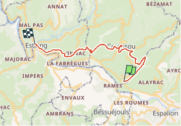

Length
11.7 km

Max alt
481 m

Uphill gradient
370 m
Km-Effort
16.6 km

Min alt
317 m

Downhill gradient
383 m
Boucle
No
Creation date :
2025-07-21 15:35:50.035
Updated on :
2025-07-21 15:36:36.218
3h46
Difficulty : Difficult

FREE GPS app for hiking
 SityTrail
IGN / Geographical institutes
SityTrail Plus
The world is yours!
About
Trail Walking of 11.7 km to be discovered at Occitania, Aveyron, Coubisou. This trail is proposed by michel38.
Positioning
Country:
France
Region :
Occitania
Department/Province :
Aveyron
Municipality :
Coubisou
Location:
Unknown
Start:(Dec)
Start:(UTM)
478792 ; 4931440 (31T) N.
Comments