


Matour 16km Marche sout

alain.lespinasse42@
User
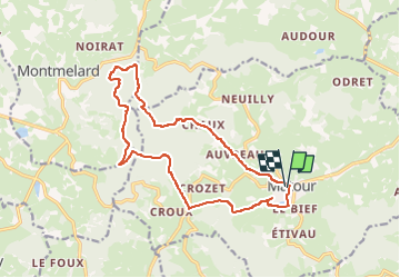

Length
16 km

Max alt
765 m

Uphill gradient
621 m
Km-Effort
24 km

Min alt
405 m

Downhill gradient
621 m
Boucle
Yes
Creation date :
2025-07-21 20:47:38.269
Updated on :
2025-07-21 20:49:34.238
5h30
Difficulty : Medium

FREE GPS app for hiking
 SityTrail
IGN / Geographical institutes
SityTrail Plus
The world is yours!
About
Trail On foot of 16 km to be discovered at Bourgogne-Franche-Comté, Saône-et-Loire, Matour. This trail is proposed by alain.lespinasse42@.
Description
passage au mont Saint Cyr
Positioning
Country:
France
Region :
Bourgogne-Franche-Comté
Department/Province :
Saône-et-Loire
Municipality :
Matour
Location:
Unknown
Start:(Dec)
Start:(UTM)
614013 ; 5129207 (31T) N.
Comments
tu