


Parcours pédestre N°1

donda
User GUIDE
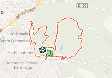

Length
3.1 km

Max alt
146 m

Uphill gradient
98 m
Km-Effort
4.4 km

Min alt
58 m

Downhill gradient
98 m
Boucle
Yes
Creation date :
2025-07-22 05:18:38.815
Updated on :
2025-07-25 06:50:29.807
45m
Difficulty : Easy

FREE GPS app for hiking
 SityTrail
IGN / Geographical institutes
SityTrail Plus
The world is yours!
About
Trail Walking of 3.1 km to be discovered at Provence-Alpes-Côte d'Azur, Var, Saint-Raphaël. This trail is proposed by donda.
Description
Parcours pédestre (1er variante)
Positioning
Country:
France
Region :
Provence-Alpes-Côte d'Azur
Department/Province :
Var
Municipality :
Saint-Raphaël
Location:
Unknown
Start:(Dec)
Start:(UTM)
322792 ; 4810744 (32T) N.
Comments