


etp33. gr11

tosan
User
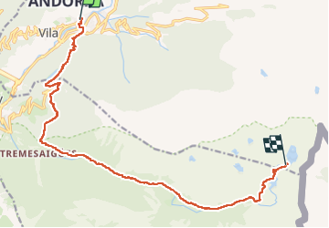

Length
16.9 km

Max alt
2501 m

Uphill gradient
1424 m
Km-Effort
32 km

Min alt
1242 m

Downhill gradient
195 m
Boucle
No
Creation date :
2025-07-20 04:33:18.27
Updated on :
2025-07-22 11:06:07.802
6h07
Difficulty : Very difficult

FREE GPS app for hiking
 SityTrail
IGN / Geographical institutes
SityTrail Plus
The world is yours!
About
Trail Walking of 16.9 km to be discovered at Andorra. This trail is proposed by tosan.
Photos

Positioning
Country:
Andorra
Region :
Unknown
Department/Province :
Unknown
Municipality :
Unknown
Location:
Unknown
Start:(Dec)
Start:(UTM)
383264 ; 4710237 (31T) N.
Comments