


Courlevon

Jluc02
User
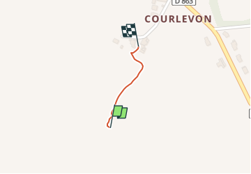

Length
233 m

Max alt
138 m

Uphill gradient
0 m
Km-Effort
236 m

Min alt
136 m

Downhill gradient
1 m
Boucle
Yes
Creation date :
2025-07-22 13:00:06.0
Updated on :
2025-07-22 13:07:36.102
7m
Difficulty : Easy

FREE GPS app for hiking
 SityTrail
IGN / Geographical institutes
SityTrail Plus
The world is yours!
About
Trail Walking of 233 m to be discovered at Hauts-de-France, Aisne, Montfaucon. This trail is proposed by Jluc02.

Positioning
Country:
France
Region :
Hauts-de-France
Department/Province :
Aisne
Municipality :
Montfaucon
Location:
Unknown
Start:(Dec)
Start:(UTM)
530762 ; 5421635 (31U) N.
Comments