


cheptainville

Auger91
User
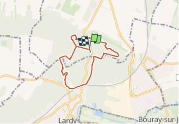

Length
6.7 km

Max alt
160 m

Uphill gradient
128 m
Km-Effort
8.4 km

Min alt
78 m

Downhill gradient
129 m
Boucle
Yes
Creation date :
2025-07-22 11:40:50.896
Updated on :
2025-07-22 13:55:28.75
1h58
Difficulty : Medium

FREE GPS app for hiking
 SityTrail
IGN / Geographical institutes
SityTrail Plus
The world is yours!
About
Trail Walking of 6.7 km to be discovered at Ile-de-France, Essonne, Cheptainville. This trail is proposed by Auger91.
Positioning
Country:
France
Region :
Ile-de-France
Department/Province :
Essonne
Municipality :
Cheptainville
Location:
Unknown
Start:(Dec)
Start:(UTM)
446332 ; 5376213 (31U) N.
Comments