


gerardmer

jcschubnel
User
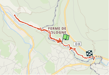

Length
5.6 km

Max alt
710 m

Uphill gradient
126 m
Km-Effort
7.2 km

Min alt
626 m

Downhill gradient
103 m
Boucle
No
Creation date :
2025-06-24 13:57:37.56
Updated on :
2025-07-22 16:23:31.994
2h02
Difficulty : Medium

FREE GPS app for hiking
 SityTrail
IGN / Geographical institutes
SityTrail Plus
The world is yours!
About
Trail Walking of 5.6 km to be discovered at Grand Est, Vosges, Xonrupt-Longemer. This trail is proposed by jcschubnel.
Positioning
Country:
France
Region :
Grand Est
Department/Province :
Vosges
Municipality :
Xonrupt-Longemer
Location:
Unknown
Start:(Dec)
Start:(UTM)
343667 ; 5328132 (32U) N.
Comments