


Col de la Cayolle - Lac petite Cayolle et lac des Garrets

soca
User
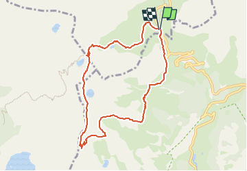

Length
8.9 km

Max alt
2675 m

Uphill gradient
437 m
Km-Effort
14.7 km

Min alt
2265 m

Downhill gradient
433 m
Boucle
Yes
Creation date :
2025-07-22 19:05:58.013
Updated on :
2025-07-22 19:15:07.09
3h20
Difficulty : Difficult

FREE GPS app for hiking
 SityTrail
IGN / Geographical institutes
SityTrail Plus
The world is yours!
About
Trail Walking of 8.9 km to be discovered at Provence-Alpes-Côte d'Azur, Alpes-de-Haute-Provence, Uvernet-Fours. This trail is proposed by soca.
Positioning
Country:
France
Region :
Provence-Alpes-Côte d'Azur
Department/Province :
Alpes-de-Haute-Provence
Municipality :
Uvernet-Fours
Location:
Unknown
Start:(Dec)
Start:(UTM)
319879 ; 4903231 (32T) N.
Comments