


chemin jp

jpmv
User
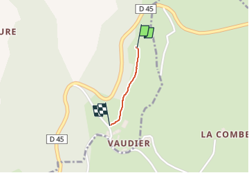

Length
433 m

Max alt
740 m

Uphill gradient
1 m
Km-Effort
496 m

Min alt
717 m

Downhill gradient
16 m
Boucle
No
Creation date :
2025-07-22 19:29:08.685
Updated on :
2025-07-22 19:41:45.078
12m
Difficulty : Easy

FREE GPS app for hiking
 SityTrail
IGN / Geographical institutes
SityTrail Plus
The world is yours!
About
Trail Walking of 433 m to be discovered at Auvergne-Rhône-Alpes, Loire, Saint-Just-en-Chevalet. This trail is proposed by jpmv.
Positioning
Country:
France
Region :
Auvergne-Rhône-Alpes
Department/Province :
Loire
Municipality :
Saint-Just-en-Chevalet
Location:
Unknown
Start:(Dec)
Start:(UTM)
567833 ; 5085702 (31T) N.
Comments