


ligne j4 la serve roche de Solutré

ophness
User
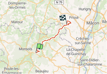

Length
26 km

Max alt
735 m

Uphill gradient
785 m
Km-Effort
38 km

Min alt
262 m

Downhill gradient
1102 m
Boucle
No
Creation date :
2025-07-23 15:18:38.99
Updated on :
2025-07-23 15:18:45.382
4h57
Difficulty : Difficult

FREE GPS app for hiking
 SityTrail
IGN / Geographical institutes
SityTrail Plus
The world is yours!
About
Trail Horseback riding of 26 km to be discovered at Auvergne-Rhône-Alpes, Rhône, Deux-Grosnes. This trail is proposed by ophness.
Positioning
Country:
France
Region :
Auvergne-Rhône-Alpes
Department/Province :
Rhône
Municipality :
Deux-Grosnes
Location:
Ouroux
Start:(Dec)
Start:(UTM)
621078 ; 5118190 (31T) N.
Comments