


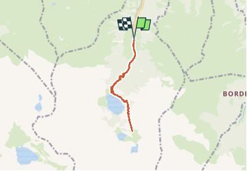
J9-Lacs Oo et Estingo

ETMU5496
User


5h38
Difficulty : Medium

FREE GPS app for hiking
 SityTrail
IGN / Geographical institutes
SityTrail Plus
The world is yours!
About
Trail Walking of 13 km to be discovered at Occitania, Haute-Garonne, Oô. This trail is proposed by ETMU5496.
Description
Belle randonnée jusqu'au lac d'Oô, son refuge et sa superbe cascade.
Poursuite avec un terrain plus difficile jusqu'au col d'Estingo, son refuge et son lac.
IBP=93
Photos


30 photos in total. Please click on a photo to see them all in the gallery.
Positioning
Comments