


Toulouse JP

ClubAgeHeureux
User
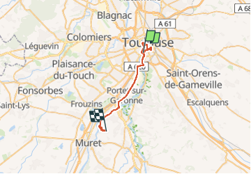

Length
29 km

Max alt
168 m

Uphill gradient
252 m
Km-Effort
33 km

Min alt
129 m

Downhill gradient
227 m
Boucle
No
Creation date :
2025-07-24 06:59:22.475
Updated on :
2025-07-24 14:32:15.045
7h32
Difficulty : Very difficult

FREE GPS app for hiking
 SityTrail
IGN / Geographical institutes
SityTrail Plus
The world is yours!
About
Trail Walking of 29 km to be discovered at Occitania, Haute-Garonne, Toulouse. This trail is proposed by ClubAgeHeureux.
Photos


22 photos in total. Please click on a photo to see them all in the gallery.
Positioning
Country:
France
Region :
Occitania
Department/Province :
Haute-Garonne
Municipality :
Toulouse
Location:
Unknown
Start:(Dec)
Start:(UTM)
373768 ; 4827501 (31T) N.
Comments