


=> Ambert
© OpenStreetMap contributors


27m
Difficulty : Unknown


Length
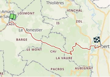
11.5 km
Max alt
982 m
Uphill gradient
37 m
Km-Effort
13.5 km
Min alt
523 m
Downhill gradient
480 m
Boucle
No
Creation date :
2025-07-25 08:54:10.0
Updated on :
2025-07-25 09:41:23.541
27m
Difficulty : Unknown
FREE GPS app for hiking
 SityTrail
IGN / Geographical institutes
SityTrail Plus
The world is yours!
About
Trail Camping car of 11.5 km to be discovered at Auvergne-Rhône-Alpes, Puy-de-Dôme, Le Monestier. This trail is proposed by 001176.05285939d7c848918be5cbf93d931c37.0558.
Positioning
Country:
France
Region :
Auvergne-Rhône-Alpes
Department/Province :
Puy-de-Dôme
Municipality :
Le Monestier
Location:
Unknown
Start:(Dec)
Start:(UTM)
549790 ; 5046271 (31T) N.
Comments