


Sombrun 1

iznogud
User
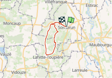

Length
10.8 km

Max alt
295 m

Uphill gradient
231 m
Km-Effort
13.9 km

Min alt
187 m

Downhill gradient
231 m
Boucle
Yes
Creation date :
2025-07-25 09:16:59.0
Updated on :
2025-07-25 11:40:41.758

FREE GPS app for hiking
 SityTrail
IGN / Geographical institutes
SityTrail Plus
The world is yours!
About
Trail of 10.8 km to be discovered at Occitania, Hautespyrenees, Sombrun. This trail is proposed by iznogud.
Positioning
Country:
France
Region :
Occitania
Department/Province :
Hautespyrenees
Municipality :
Sombrun
Location:
Unknown
Start:(Dec)
Start:(UTM)
257725 ; 4818457 (31T) N.
Comments