Trail Mountain bike Esch-sur-Alzette - 
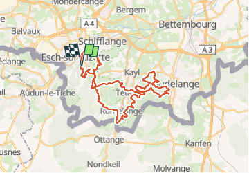
VTT Terres rouges Lux - Photo
 Zlatorog
Zlatorog

User

© OpenStreetMap contributors
Length
Length
38 km
Max alt
Max alt
425 m
Uphill gradient
Uphill gradient
738 m
Km-Effort
Km-Effort  
48 km
Min alt
Min alt
284 m
Downhill gradient
Downhill gradient
740 m
Boucle
Boucle
Yes
Creation date :
2025-07-25 12:39:39.348
Updated on :
2025-07-26 04:33:19.291

(0 Reviews)

Mountain bike
Mountain bike
4h04
Difficulty : Medium

Scan this QR Code to open this trail in the SityTrail application

FREE GPS app for hiking

Logo SityTrail SityTrail

IGN / Geographical institutes

Download SityTrail from the App Store Download SityTrail from Google Play

Logo SityTrail SityTrail Plus

The world is yours!

Download SityTrail from the App Store Download SityTrail from Google Play Download SityTrail on Huawei AppGallery

About

Trail Mountain bike of 38 km to be discovered at Unknown, Canton Esch-sur-Alzette, Esch-sur-Alzette. This trail is proposed by Zlatorog.

Description

superbe parcours VTT qui se déroule principalement dans les anciennes mines de fer à ciel ouvert autour d'Esch sur Alzette. Parcours principalement en single et en sous-bois. Pas très technique mais toujours très agréable il offre une opportunité de faire du beau VTT. Le terrain des terres rouges est drainant ce qui permet de rouler sur terrain assez sec quand les sentiers alentours sont boueux et impraticables.

Elevation profile

Positioning

Country:
Luxembourg
Region :
Unknown
Department/Province :
Canton Esch-sur-Alzette
Municipality :
Esch-sur-Alzette
Location:
Park
Start:(UTM)
716649 ; 5486187 (31U) N.


Close
My subscriptions