


Avignon jour 1

jeff2
User
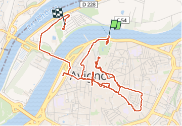

Length
7.9 km

Max alt
45 m

Uphill gradient
80 m
Km-Effort
8.9 km

Min alt
17 m

Downhill gradient
77 m
Boucle
No
Creation date :
2025-07-25 14:24:48.084
Updated on :
2025-07-25 21:52:52.55
7h27
Difficulty : Very easy

FREE GPS app for hiking
 SityTrail
IGN / Geographical institutes
SityTrail Plus
The world is yours!
About
Trail Walking of 7.9 km to be discovered at Provence-Alpes-Côte d'Azur, Vaucluse, Avignon. This trail is proposed by jeff2.
Description
Balade au festival
Positioning
Country:
France
Region :
Provence-Alpes-Côte d'Azur
Department/Province :
Vaucluse
Municipality :
Avignon
Location:
Unknown
Start:(Dec)
Start:(UTM)
645123 ; 4868366 (31T) N.
Comments