


montée de Plan Praz

micheljullien
User
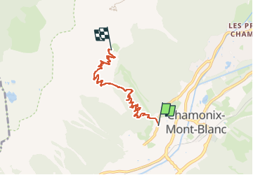

Length
5.3 km

Max alt
2050 m

Uphill gradient
958 m
Km-Effort
14.9 km

Min alt
1091 m

Downhill gradient
2 m
Boucle
No
Creation date :
2025-07-26 07:40:30.422
Updated on :
2025-07-26 09:27:42.732
1h46
Difficulty : Difficult

FREE GPS app for hiking
 SityTrail
IGN / Geographical institutes
SityTrail Plus
The world is yours!
About
Trail Walking of 5.3 km to be discovered at Auvergne-Rhône-Alpes, Upper Savoy, Chamonix-Mont-Blanc. This trail is proposed by micheljullien.
Positioning
Country:
France
Region :
Auvergne-Rhône-Alpes
Department/Province :
Upper Savoy
Municipality :
Chamonix-Mont-Blanc
Location:
Unknown
Start:(Dec)
Start:(UTM)
334343 ; 5087836 (32T) N.
Comments