


Juclar

crognon
User
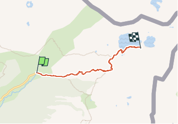

Length
4.5 km

Max alt
2333 m

Uphill gradient
494 m
Km-Effort
9.5 km

Min alt
1833 m

Downhill gradient
16 m
Boucle
No
Creation date :
2025-07-21 11:23:22.149
Updated on :
2025-07-26 10:14:11.029
4h31
Difficulty : Medium

FREE GPS app for hiking
 SityTrail
IGN / Geographical institutes
SityTrail Plus
The world is yours!
About
Trail Walking of 4.5 km to be discovered at Andorra. This trail is proposed by crognon.
Positioning
Country:
Andorra
Region :
Unknown
Department/Province :
Unknown
Municipality :
Unknown
Location:
Unknown
Start:(Dec)
Start:(UTM)
392237 ; 4717483 (31T) N.
Comments