


Ste Croix de Caderle

ARVIEU
User

Length
17.3 km

Max alt
614 m

Uphill gradient
599 m
Km-Effort
25 km

Min alt
213 m

Downhill gradient
600 m
Boucle
Yes
Creation date :
2025-07-27 09:09:45.114
Updated on :
2025-07-27 09:12:32.93
5h00
Difficulty : Medium

FREE GPS app for hiking
 SityTrail
IGN / Geographical institutes
SityTrail Plus
The world is yours!
About
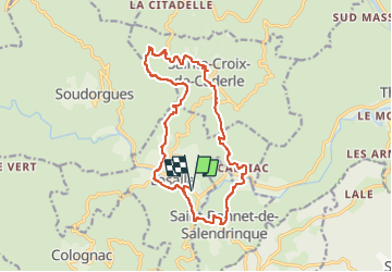
Trail Walking of 17.3 km to be discovered at Occitania, Gard, Lasalle. This trail is proposed by ARVIEU.
Description
Départ Lasalle - Ste Croix de Caderle - Le Menhir - Le Moulin - Château de St Bonnet de la Salendrinque - Lasalle
Photos


Positioning
Country:
France
Region :
Occitania
Department/Province :
Gard
Municipality :
Lasalle
Location:
Unknown
Start:(Dec)
Start:(UTM)
568919 ; 4876974 (31T) N.
Comments