


Eveux

hearly
User
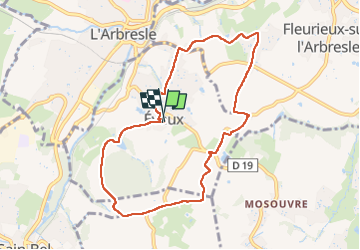

Length
8.7 km

Max alt
426 m

Uphill gradient
225 m
Km-Effort
11.7 km

Min alt
271 m

Downhill gradient
225 m
Boucle
Yes
Creation date :
2025-07-27 06:59:47.0
Updated on :
2025-07-27 09:33:56.781

FREE GPS app for hiking
 SityTrail
IGN / Geographical institutes
SityTrail Plus
The world is yours!
About
Trail of 8.7 km to be discovered at Auvergne-Rhône-Alpes, Rhône, Éveux. This trail is proposed by hearly.
Positioning
Country:
France
Region :
Auvergne-Rhône-Alpes
Department/Province :
Rhône
Municipality :
Éveux
Location:
Unknown
Start:(Dec)
Start:(UTM)
626087 ; 5075949 (31T) N.
Comments