


vers Nucourt 2 test

alainchardon
User
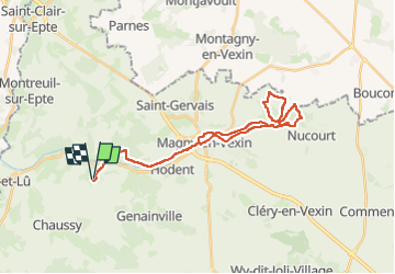

Length
31 km

Max alt
129 m

Uphill gradient
395 m
Km-Effort
36 km

Min alt
47 m

Downhill gradient
396 m
Boucle
Yes
Creation date :
2025-07-27 07:08:22.222
Updated on :
2025-07-27 10:45:46.991
3h36
Difficulty : Medium

FREE GPS app for hiking
 SityTrail
IGN / Geographical institutes
SityTrail Plus
The world is yours!
About
Trail Mountain bike of 31 km to be discovered at Ile-de-France, Val-d'Oise, Omerville. This trail is proposed by alainchardon.
Positioning
Country:
France
Region :
Ile-de-France
Department/Province :
Val-d'Oise
Municipality :
Omerville
Location:
Unknown
Start:(Dec)
Start:(UTM)
406431 ; 5443883 (31U) N.
Comments