


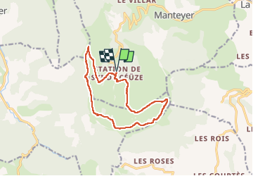
PIC DE CEUSE

nordan
User

Length
13.2 km

Max alt
2014 m

Uphill gradient
715 m
Km-Effort
23 km

Min alt
1520 m

Downhill gradient
715 m
Boucle
Yes
Creation date :
2025-07-26 08:23:45.638
Updated on :
2025-07-27 14:30:03.677
3h46
Difficulty : Medium

FREE GPS app for hiking
 SityTrail
IGN / Geographical institutes
SityTrail Plus
The world is yours!
About
Trail Walking of 13.2 km to be discovered at Provence-Alpes-Côte d'Azur, Hautes-Alpes, Manteyer. This trail is proposed by nordan.
Positioning
Country:
France
Region :
Provence-Alpes-Côte d'Azur
Department/Province :
Hautes-Alpes
Municipality :
Manteyer
Location:
Unknown
Start:(Dec)
Start:(UTM)
733407 ; 4933672 (31T) N.
Comments