


PIC AIGLE LUS

nordan
User
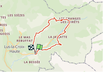

Length
14.9 km

Max alt
1720 m

Uphill gradient
835 m
Km-Effort
26 km

Min alt
1061 m

Downhill gradient
846 m
Boucle
Yes
Creation date :
2025-07-27 07:26:46.372
Updated on :
2025-07-27 14:30:05.128
4h29
Difficulty : Medium

FREE GPS app for hiking
 SityTrail
IGN / Geographical institutes
SityTrail Plus
The world is yours!
About
Trail Walking of 14.9 km to be discovered at Auvergne-Rhône-Alpes, Drôme, Lus-la-Croix-Haute. This trail is proposed by nordan.
Positioning
Country:
France
Region :
Auvergne-Rhône-Alpes
Department/Province :
Drôme
Municipality :
Lus-la-Croix-Haute
Location:
Unknown
Start:(Dec)
Start:(UTM)
716540 ; 4948999 (31T) N.
Comments