


la maltiere apigne boucle 10,5

Pascal Gueno
User
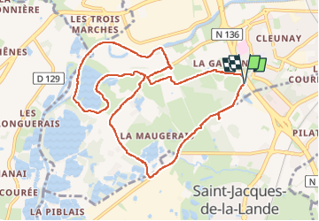

Length
10.7 km

Max alt
40 m

Uphill gradient
75 m
Km-Effort
11.7 km

Min alt
18 m

Downhill gradient
76 m
Boucle
Yes
Creation date :
2025-07-27 12:16:25.59
Updated on :
2025-07-27 14:39:04.937
1h59
Difficulty : Very easy

FREE GPS app for hiking
 SityTrail
IGN / Geographical institutes
SityTrail Plus
The world is yours!
About
Trail Walking of 10.7 km to be discovered at Brittany, Ille-et-Vilaine, Rennes. This trail is proposed by Pascal Gueno.
Description
parking de la maltiere à St jacques
Positioning
Country:
France
Region :
Brittany
Department/Province :
Ille-et-Vilaine
Municipality :
Rennes
Location:
Quartiers Ouest
Start:(Dec)
Start:(UTM)
595859 ; 5327743 (30U) N.
Comments