


Clapiers Les Lavagnes

ARVIEU
User
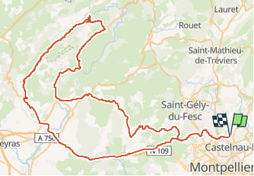

Length
127 km

Max alt
562 m

Uphill gradient
1821 m
Km-Effort
151 km

Min alt
40 m

Downhill gradient
1821 m
Boucle
Yes
Creation date :
2025-07-27 18:39:16.849
Updated on :
2025-07-27 18:41:11.015
5h00
Difficulty : Difficult

FREE GPS app for hiking
 SityTrail
IGN / Geographical institutes
SityTrail Plus
The world is yours!
About
Trail Cycle of 127 km to be discovered at Occitania, Hérault, Clapiers. This trail is proposed by ARVIEU.
Description
Clapiers Argeliers St Guilhem Causse de la Celle Pégairolles de Buèges Les Lavagnes Montpeyroux Gignac St Paul et Valmalle
Bel Air Grabels Clapiers
Positioning
Country:
France
Region :
Occitania
Department/Province :
Hérault
Municipality :
Clapiers
Location:
Unknown
Start:(Dec)
Start:(UTM)
571921 ; 4833927 (31T) N.
Comments