


Col des Marrous, Col de Péguère et Col de Port depuis Tarascon sur Ariège

chrisbal
User
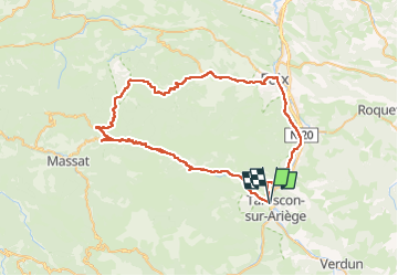

Length
70 km

Max alt
1385 m

Uphill gradient
1631 m
Km-Effort
92 km

Min alt
390 m

Downhill gradient
1629 m
Boucle
Yes
Creation date :
2025-07-27 18:42:12.939
Updated on :
2025-08-13 07:34:18.71
5h33
Difficulty : Difficult

FREE GPS app for hiking
 SityTrail
IGN / Geographical institutes
SityTrail Plus
The world is yours!
About
Trail Road bike of 70 km to be discovered at Occitania, Ariège, Tarascon-sur-Ariège. This trail is proposed by chrisbal.
Positioning
Country:
France
Region :
Occitania
Department/Province :
Ariège
Municipality :
Tarascon-sur-Ariège
Location:
Unknown
Start:(Dec)
Start:(UTM)
385558 ; 4745123 (31T) N.
Comments