Trail Walking Saint-Genès-Champanelle - Nadaillat_Cassiere - Photo
 jagarnier
jagarnier

User GUIDE

© OpenStreetMap contributors
Length
Length
10.6 km
Max alt
Max alt
1037 m
Uphill gradient
Uphill gradient
301 m
Km-Effort
Km-Effort  
14.7 km
Min alt
Min alt
864 m
Downhill gradient
Downhill gradient
304 m
Boucle
Boucle
Yes
Creation date :
2025-07-28 03:52:48.924
Updated on :
2025-07-28 04:03:11.591

(0 Reviews)

Walking
Walking
3h15
Difficulty : Medium

Scan this QR Code to open this trail in the SityTrail application

FREE GPS app for hiking

Logo SityTrail SityTrail

IGN / Geographical institutes

Download SityTrail from the App Store Download SityTrail from Google Play

Logo SityTrail SityTrail Plus

The world is yours!

Download SityTrail from the App Store Download SityTrail from Google Play Download SityTrail on Huawei AppGallery

About

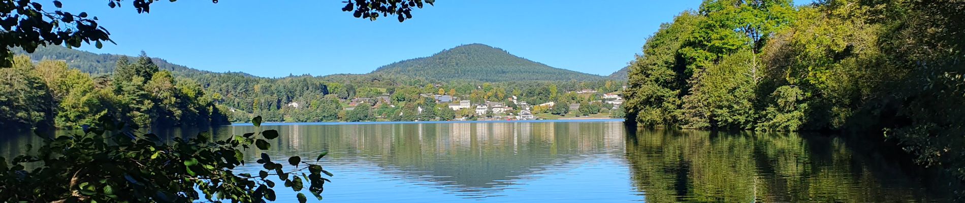
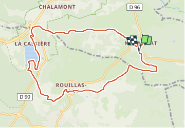
Trail Walking of 10.6 km to be discovered at Auvergne-Rhône-Alpes, Puy-de-Dôme, Saint-Genès-Champanelle. This trail is proposed by jagarnier.

Description

Au départ de Nadaillat, joli village sur la Montagne de la Serre, une randonnée à travers champs et prés pour rejoindre les rives du Lac de la Cassière. Au retour, vous passerez passe par Rouillat-Haut, petit village où vous pourrez voir des plaques de rue en lave émaillée.

Elevation profile

Photos

Positioning

Country:
France
Region :
Auvergne-Rhône-Alpes
Department/Province :
Puy-de-Dôme
Municipality :
Saint-Genès-Champanelle
Location:
Unknown
Start:(UTM)
502591 ; 5059442 (31T) N.


Close
My subscriptions