


sezanne

erisel
User

Length
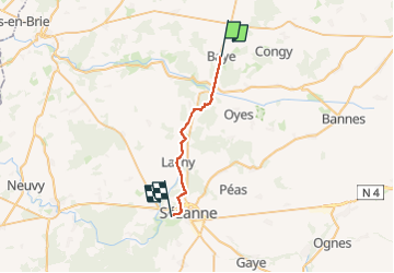
21 km

Max alt
224 m

Uphill gradient
253 m
Km-Effort
25 km

Min alt
136 m

Downhill gradient
277 m
Boucle
No
Creation date :
2025-07-28 06:42:07.844
Updated on :
2025-07-28 14:03:23.02
7h20
Difficulty : Very difficult

FREE GPS app for hiking
 SityTrail
IGN / Geographical institutes
SityTrail Plus
The world is yours!
About
Trail Walking of 21 km to be discovered at Grand Est, Marne, Baye. This trail is proposed by erisel.
Positioning
Country:
France
Region :
Grand Est
Department/Province :
Marne
Municipality :
Baye
Location:
Unknown
Start:(Dec)
Start:(UTM)
556028 ; 5411498 (31U) N.
Comments