


Nieuwpoort -oostduinkerke
© OpenStreetMap contributors


1h20
Difficulty : Medium


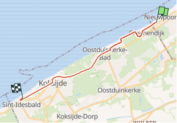
Length
9 km
Max alt
18 m
Uphill gradient
67 m
Km-Effort
9.9 km
Min alt
-1 m
Downhill gradient
64 m
Boucle
No
Creation date :
2025-07-28 13:51:43.0
Updated on :
2025-07-28 16:04:06.9
1h20
Difficulty : Medium
FREE GPS app for hiking
 SityTrail
IGN / Geographical institutes
SityTrail Plus
The world is yours!
About
Trail Walking of 9 km to be discovered at Flanders, West Flanders, Nieuwpoort. This trail is proposed by 000964.fa9d780e791c4b0e87b0942d7642966f.1926.
Description
Dans le dunes et le long de la olagr
Positioning
Country:
Belgium
Region :
Flanders
Department/Province :
West Flanders
Municipality :
Nieuwpoort
Location:
Unknown
Start:(Dec)
Start:(UTM)
479525 ; 5666040 (31U) N.
Comments