


lac laramont

brigitBB26
User

Length
12.7 km

Max alt
2412 m

Uphill gradient
759 m
Km-Effort
22 km

Min alt
1780 m

Downhill gradient
533 m
Boucle
No
Creation date :
2025-07-25 08:26:29.794
Updated on :
2025-07-28 16:09:35.281
5h35
Difficulty : Medium

FREE GPS app for hiking
 SityTrail
IGN / Geographical institutes
SityTrail Plus
The world is yours!
About
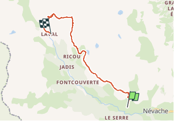
Trail Walking of 12.7 km to be discovered at Provence-Alpes-Côte d'Azur, Hautes-Alpes, Névache. This trail is proposed by brigitBB26.
Positioning
Country:
France
Region :
Provence-Alpes-Côte d'Azur
Department/Province :
Hautes-Alpes
Municipality :
Névache
Location:
Unknown
Start:(Dec)
Start:(UTM)
309644 ; 4988125 (32T) N.
Comments