


chatillon azergues

Poupette Dumay
User
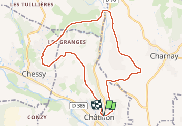

Length
9.7 km

Max alt
341 m

Uphill gradient
212 m
Km-Effort
12.5 km

Min alt
212 m

Downhill gradient
215 m
Boucle
Yes
Creation date :
2025-07-29 06:54:44.965
Updated on :
2025-07-29 09:36:12.662
2h41
Difficulty : Difficult

FREE GPS app for hiking
 SityTrail
IGN / Geographical institutes
SityTrail Plus
The world is yours!
About
Trail Walking of 9.7 km to be discovered at Auvergne-Rhône-Alpes, Rhône, Châtillon. This trail is proposed by Poupette Dumay .
Positioning
Country:
France
Region :
Auvergne-Rhône-Alpes
Department/Province :
Rhône
Municipality :
Châtillon
Location:
Unknown
Start:(Dec)
Start:(UTM)
627782 ; 5081714 (31T) N.
Comments