


St Nazaire en Ryns

aldaus
User
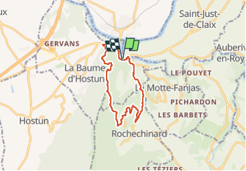

Length
11.9 km

Max alt
584 m

Uphill gradient
498 m
Km-Effort
18.5 km

Min alt
166 m

Downhill gradient
503 m
Boucle
Yes
Creation date :
2025-07-27 08:19:31.102
Updated on :
2025-07-29 12:50:19.282
3h22
Difficulty : Difficult

FREE GPS app for hiking
 SityTrail
IGN / Geographical institutes
SityTrail Plus
The world is yours!
About
Trail Walking of 11.9 km to be discovered at Auvergne-Rhône-Alpes, Drôme, Saint-Nazaire-en-Royans. This trail is proposed by aldaus.
Positioning
Country:
France
Region :
Auvergne-Rhône-Alpes
Department/Province :
Drôme
Municipality :
Saint-Nazaire-en-Royans
Location:
Unknown
Start:(Dec)
Start:(UTM)
676705 ; 4992074 (31T) N.
Comments