


Saint André les alpes (le Courchon)

darranger
User
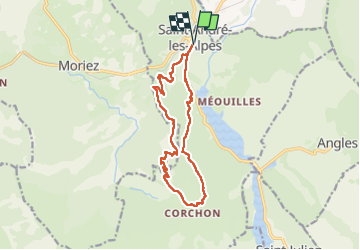

Length
14.4 km

Max alt
1355 m

Uphill gradient
618 m
Km-Effort
23 km

Min alt
881 m

Downhill gradient
618 m
Boucle
Yes
Creation date :
2025-07-29 08:04:11.248
Updated on :
2025-07-29 14:13:38.718
4h08
Difficulty : Very difficult

FREE GPS app for hiking
 SityTrail
IGN / Geographical institutes
SityTrail Plus
The world is yours!
About
Trail Walking of 14.4 km to be discovered at Provence-Alpes-Côte d'Azur, Alpes-de-Haute-Provence, Saint-André-les-Alpes. This trail is proposed by darranger.
Description
très belle randonnée sentier très agréable, à l'ombre et des vues magnifiques
Positioning
Country:
France
Region :
Provence-Alpes-Côte d'Azur
Department/Province :
Alpes-de-Haute-Provence
Municipality :
Saint-André-les-Alpes
Location:
Unknown
Start:(Dec)
Start:(UTM)
300175 ; 4871278 (32T) N.
Comments