


Rochesson de nuit

juliengsell
User
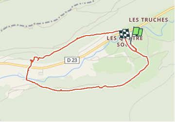

Length
4.6 km

Max alt
672 m

Uphill gradient
193 m
Km-Effort
7.2 km

Min alt
554 m

Downhill gradient
191 m
Boucle
Yes
Creation date :
2025-07-29 18:39:25.0
Updated on :
2025-07-29 20:12:59.021

FREE GPS app for hiking
 SityTrail
IGN / Geographical institutes
SityTrail Plus
The world is yours!
About
Trail of 4.6 km to be discovered at Grand Est, Vosges, Rochesson. This trail is proposed by juliengsell.
Positioning
Country:
France
Region :
Grand Est
Department/Province :
Vosges
Municipality :
Rochesson
Location:
Unknown
Start:(Dec)
Start:(UTM)
337481 ; 5321729 (32U) N.
Comments