


M2Garderes

LouisROGER
User GUIDE
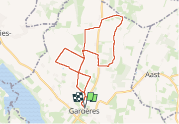

Length
9.8 km

Max alt
407 m

Uphill gradient
72 m
Km-Effort
10.8 km

Min alt
371 m

Downhill gradient
72 m
Boucle
Yes
Creation date :
2025-07-30 07:03:04.428
Updated on :
2025-07-30 09:42:44.296
2h39
Difficulty : Medium

FREE GPS app for hiking
 SityTrail
IGN / Geographical institutes
SityTrail Plus
The world is yours!
About
Trail Walking of 9.8 km to be discovered at Occitania, Hautespyrenees, Gardères. This trail is proposed by LouisROGER.
Positioning
Country:
France
Region :
Occitania
Department/Province :
Hautespyrenees
Municipality :
Gardères
Location:
Unknown
Start:(Dec)
Start:(UTM)
734333 ; 4795991 (30T) N.
Comments