


Pont lâAB V2

Pierrannick
User
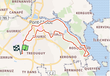

Length
10.1 km

Max alt
22 m

Uphill gradient
84 m
Km-Effort
11.2 km

Min alt
-3 m

Downhill gradient
84 m
Boucle
Yes
Creation date :
2025-07-30 08:50:44.0
Updated on :
2025-07-30 10:22:52.482
1h28
Difficulty : Unknown

FREE GPS app for hiking
 SityTrail
IGN / Geographical institutes
SityTrail Plus
The world is yours!
About
Trail Running of 10.1 km to be discovered at Brittany, Finistère, Pont-l'Abbé. This trail is proposed by Pierrannick.
Positioning
Country:
France
Region :
Brittany
Department/Province :
Finistère
Municipality :
Pont-l'Abbé
Location:
Unknown
Start:(Dec)
Start:(UTM)
407828 ; 5300759 (30T) N.
Comments